
fireTMS maps enable precise route planning for trucks. Just provide the route points and the system will show a cost-effective route with a detailed calculation of costs. With the new version of fireTMS the maps has gained features, that will help to provide reliable routes. Read the article and find out more.
In this article you will find information on:
Optimal routing
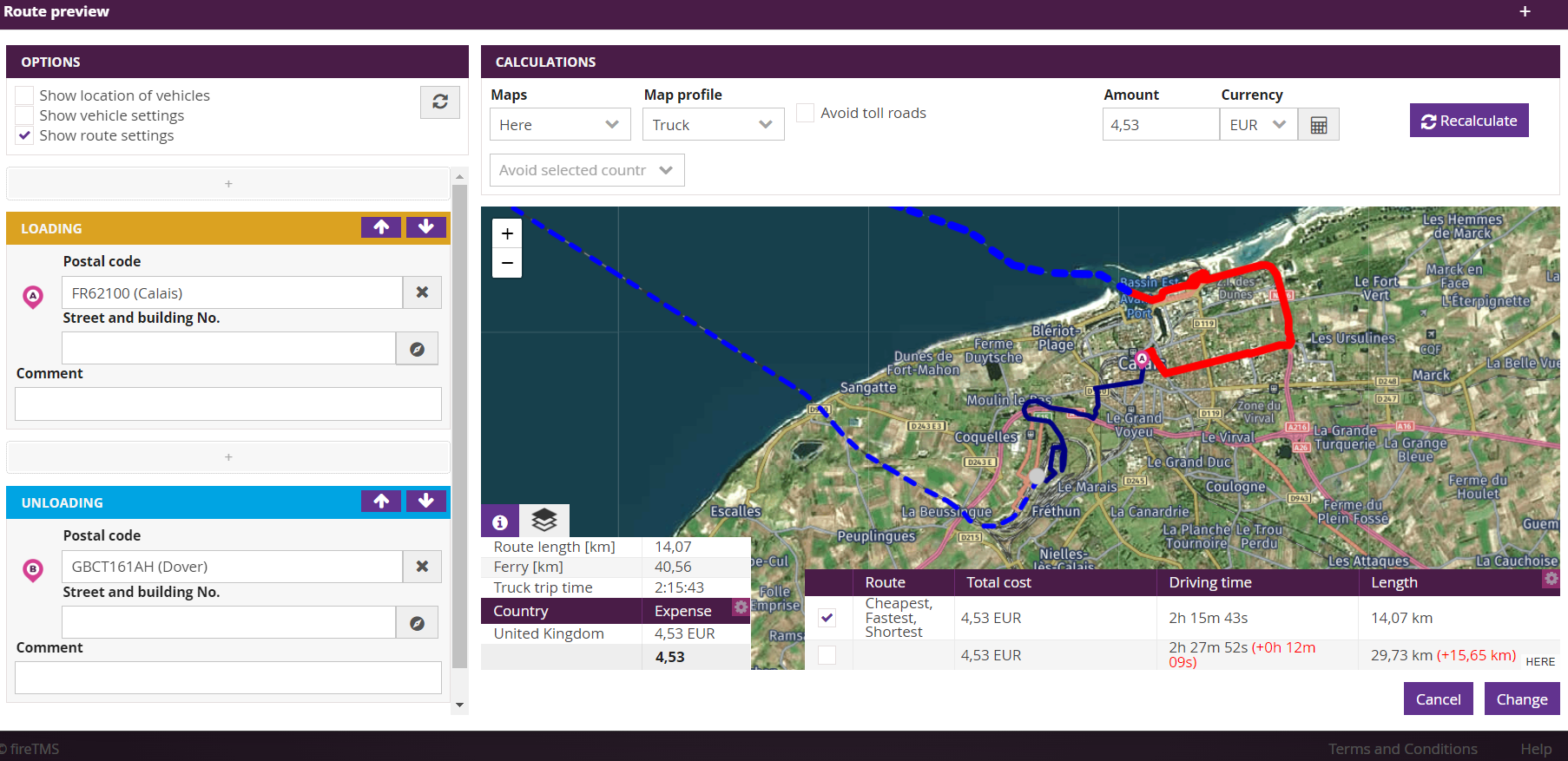
Maps in fireTMS are a professional tool for transport companies, forwarders and planners. The maps allow you to calculate the route between the specified points and provide useful information on the length of the route in kilometres, the cost of tolls, the estimated time of the drive and a suggested alternative route. The maps also allow you to calculate the cost of the route in detail, which takes into account the cost of fuel, the driver, the length of the order and the operation of the vehicle. With the tool, you can determine the shortest, fastest and cheapest route for your fleet.
Route editing with drag & drop method
The new version of the system includes the possibility to easily modify the route with drag & drop. This method is available for Here and OSM fireTMS maps. To modify a planned route, you have to grab the selected point and drag it to the preferred location. While dragging a point the new route will be suggested in real time, without having to drop this point.
Exclusion of ferry kilometres from the route calculation
Another new feature is the exclusion of the part of the route that the vehicle driven by ferry from the summary of kilometers driven by it. The deduction of ferry kilometres will automatically take into account both loading and approach kilometres. Instead, on the map part of the ferry crossing will be presented as a dashed line. This improvement applies to all maps providers available in fireTMS.
Possibility to skip selected countries during route calculation
Another new feature of maps in fireTMS is the possibility to define a list of countries to be skipped when calculating a route. You can globally specify these countries in Configuration >> System configuration >> Order handling tab >> field Countries avoided when calculating the route. Currently, this option applies only to Here maps. A new checkbox will be available in them: Show route settings. In addition to the global list of countries, you can make manual changes for each individual route.
Map backgrounds
In addition, Here maps have introduced the possibility of selecting a map background. This will make route planning easier. There are 3 options to choose from: classic, road and satellite.
If you would like to learn more about the new features in the maps, please contact us.
Information from fireTMS is as valuable as the cargo
We regularly provide information about our system and on topics in the TSL industry.
Subscribe to our newsletter and stay up to date.

Customer Support Team Leader. Posiada 7-letnie doświadczenie w zarządzaniu Działem Pomocy Technicznej. Odpowiada za wsparcie techniczne klientów fireTMS.